


?")


")


Wow, I had a wonderful road trip to explore the US Southwest, passing through breathtaking routes, spectacular national parks, magical canyons with surreal landscapes. In this article I want to share with you my great experiences I got on this memorial road trip to explore the enchanting land of Grand Circle USA for those who are planning a Grand Circle road trip itinerary to discover the legendary land.
- The ULTIMATE Yellowstone National Park Travel Guide: Top Things to Do, See, Stay, Tips & MORE
- 15+ Best & Most Beautiful National Parks in the US You Shouldn’t Miss
- Antelope Canyon travel blog — Upper Antelope vs Lower Antelope & photography tips and best camera settings for Antelope Canyon
- Bryce Canyon itinerary — How to visit Bryce Canyon in one day?
- The ULTIMATE Universal Studios Orlando travel guide & Suggested 1-day itinerary
Once upon a time, in my early twenties, I never dreamed the American dream. Because at that time in my head I pictured a country full of boring high-rise buildings, crowded roads and weird people. But on a beautiful day, fate and work pushed me to come here. Everything in America came rushing in front of me, telling me to stop imposing prejudices on a land I had never been to. Indeed, America was not the same as I had imagined. The imaginary narrow streets were replaced by wide avenues, straight highways. American culture is also a bit different from Europe, but most of the people I meet are kind, generous. And the urban skyscrapers are not so suffocating. And if compared with the surrounding spacious nature, it is just like a small island in a vast ocean.
At first sight, the green patches of high mountains, deep forests, rolling plains, interwoven with multicolored deserts have awakened in me an adventurous passion. I thought to myself, if there’s a place in the world that’s perfect for endless travel, it’s probably this country. At that moment, I knew I would return in one day.
And I’m really back. Almost right after. And I chose Grand Circle in the American Southwest for a 3-week road trip (Grand Circle road trip itinerary 3 weeks). Before those days, I never went far, just wandering between a few bustling cities and quiet villages. So that roadtrip was the starting point, paved the way for me on the journeys to come.
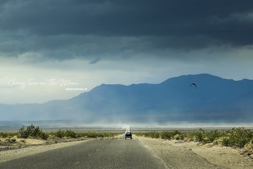
The American West is not the easiest destination one can choose for their first long-distance trip. Honestly, up until now, this is still the most desolate place I’ve ever been to. I still remember the times when the car sped through the night, I opened the window, tried to open my eyes to find a light, but only saw darkness. In my heart agitated knowing that the surrounding wilderness, a radius of a hundred kilometers around it, was not a single person. Having trouble sleeping the first night due to the difference in time zone, I listened nervously to the wolves of Death Valley howling, echoing over the cliffs near and far. Or in the other day, my campsite was alerted to rattlesnakes. So that night, my heart “stopped” a few times, listening the rustling under the bed and praying to God that no snake would come out and lick my cheek.
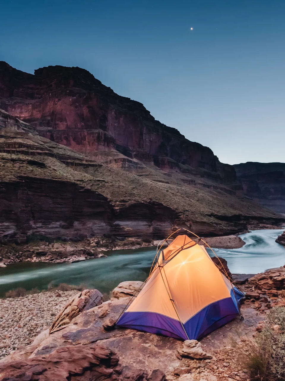
In return, those nerve stimuli are the source of adrenaline that makes us addicted. Gradually, I was no longer afraid like the first days. In the desert, I feel as small as a grain of sand. Nature surrounds me, embraces me. And on the high mountainside, I watched in awe as the sun scattered glittering bands of light down the majestic Colorado river. From dawn to dusk, day by day, in front of the ever-changing majestic landscapes, I happily waved in the open space, happily enjoying the glorious moments that belonged to me. The West poured me every sip of the golden sunshine drenched in the “scent” of freedom and before I knew it, I was already drunk.
The 3 weeks road trip is too long to wrap up in one article. However, 3 weeks is very short to explore all the way of the Grand Circle, each national park I can only stay for 1 to 3 days, consider it the first “survey” to find the most favorite place, to return in other journeys later.
This note I will dedicate to summarize the past Grand Circle road trip itinerary. In addition, the majestic and enchanting scenery of the Grand Circle USA is a paradise for those who like landscape photos. Alternating in the itinerary, I will include beautiful photo spots that I know. The Grand Circle region is mainly desert, red sandstone mountains, so sunset and dawn are the two most beautiful times to admire and take pictures here. Every day, I have a few reminders for you to go to photogenic spots at the best time of the day.
Now, let’s go together!
Grand Circle USA blog — Detailed Grand Circle road trip itinerary 3 weeks
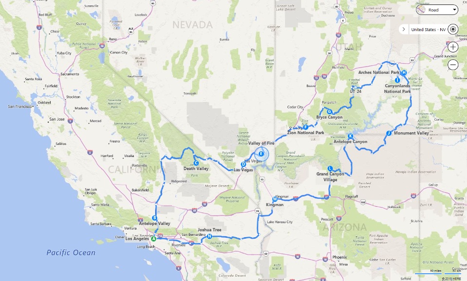
Day 1: Los Angeles
Arrive in Los Angeles, get a car at the airport, visit the city, go to the supermarket to buy food and water for long distances. Overnight in Los Angeles.
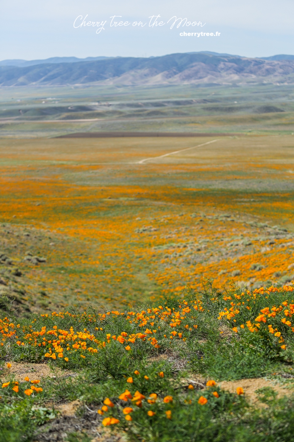
Day 2: Antelope Valley
- Driving: Los Angeles – Antelope Valley (1h30, 85 miles). Antelope Valley is a reserve of yellow poppy flowers, a desert area in the state of California. You should go to Antelope Valley after 10 am because the flowers have not yet bloomed in the early morning. Flowers only bloom in late April, early May. If you come here in another season, skip this area.
- Drive: Antelope Valley – Death Valley (2h45, 148 miles) on Trona Wildrose Road instead of Road 190. Trona Wildrose Road has more scenic views.
- Overnight in Panamint Spring, Death Valley
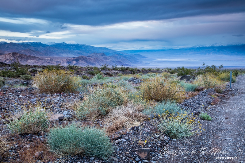
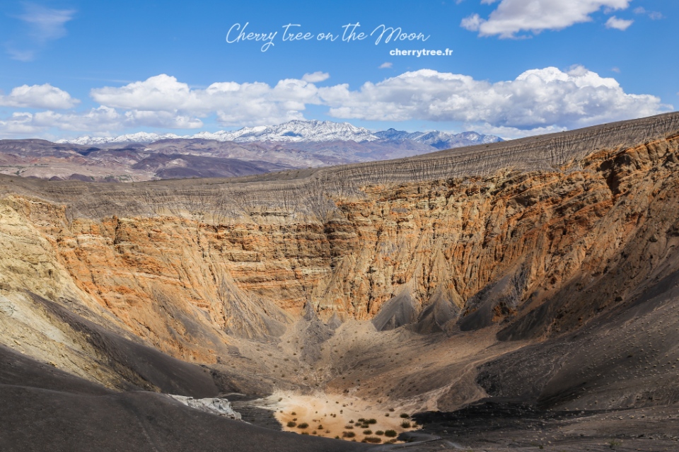
Day 3: Death Valley National Park (Np)
Death Valley, a nearly 8,000 km² national park located in eastern California, is one of the hottest regions in the world. This place is wild and has extremely diverse terrain, from desert to salt lake, high snow-capped mountains, volcanoes… Death Valley is one of the places that impressed me the most on this trip, I was always surprise with “eyes in O shape, and mouth in A shape”.
- Welcome sunrise at the sand dunes of Mesquite Flat.
- Travel along Racetrack Road to Racetrack Playa, the dry lake area is so flat that the rocks here slide across the lake surface when wind blows, creating a long trail behind. Note: The distance is 27 miles of trails, do not go in bad weather.
- Sunset at Zabriskie Point, watching the magical light is unforgettable.
- Overnight in Furnace Creek in the middle of Death Valley.
Day 4: Death Valley Np, Las Vegas
- Dawn is the best time to visit Badwater Basin, the lowest point in North America (86m below sea level). You should go far into the middle of the Basin to see the salt areas that gather into beautiful ridges.
- Drive along Artists Pallette near Badwater, see colorful sandstone.
- Driving: Death Valley – Las Vegas (2h, 118 miles).
- Overnight in Las Vegas, in a hotel in the middle of The Strip area for convenient visiting Las Vegas by night.
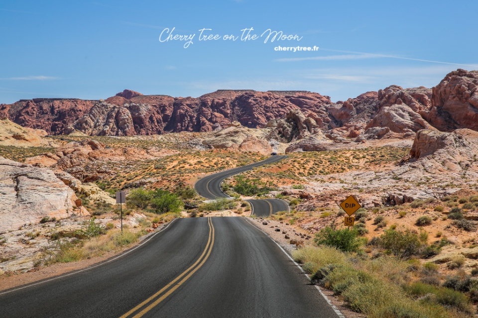
Day 5: Valley Of Fire State Park (Sp)
- Driving: Las Vegas – Valley of Fire (1h, 56 miles) on the road NV167 to get to Valley of Fire Park from the east. Valley of Fire is a Nevada state park, although not very large, but very beautiful, diverse terrain and photogenic with special sandstone structures. You should stop by here for at least a day, exploring the short trails in the area.
- Atlatl rock, Arch rock is frontlighting in the morning, perfect for take pictures, the most beautiful time is about 30 minutes after sunrise.
- Arrival in Jumble rock, Elephant rock in the mid-afternoon.
- White dome, Rainbow vista, Fire wave are most beautiful from late afternoon until sunset. These are the three most beautiful short trails of the Valley of Fire, especially at dusk. I chose Fire wave, and absolutely love the red sandstone color in the sunset.
- Overnight near the Valley of Fire.
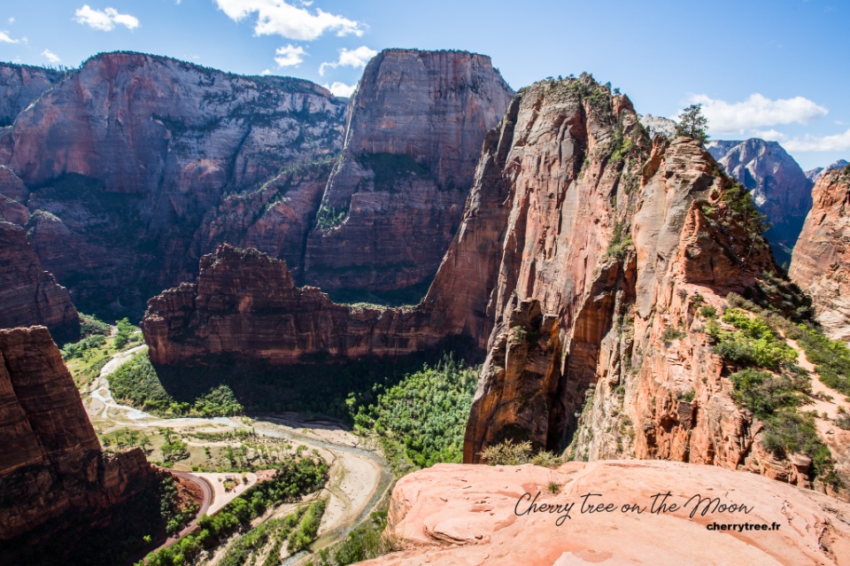
Day 6: Zion Np
- Driving: Valley of Fire – Zion NP (2h30, 140 miles). Zion is the most green national park in the region. The steep cliffs covered with pine trees are reminiscent of European mountains and forests. From spring to fall, private vehicles are not free to enter Zion Canyon. Instead, the park’s free bus takes visitors from the Zion Canyon Visitor Center all the way to the Temple of Sinawava.
- Trekking Angel’s landing (3-4 hours), Zion’s most famous trek thanks to the beautiful scenery at the end of the road and also the steepness. There are sections only 40, 50 cm wide and 400m vertical cliff on both sides. You should go early in the morning to avoid the heat because the first section is not difficult but very steep. Pay attention to consider whether to trek this route on rainy and windy days. I climbed 2/3 then had to go down because the wind was too strong to stand. In the afternoon, when hiking at Observation Point, I saw a helicopter hovering over Angel’s landing because someone fell into canyon from the cliff.
- It is said that Angel’s landing trail takes a few lives every year.
- Afternoon: Hiking Observation Point (4 hours from Weeping Rock car park).
- Driving: Zion NP – Bryce Canyon (2h, 100 miles)
- Overnight near Bryce Canyon.
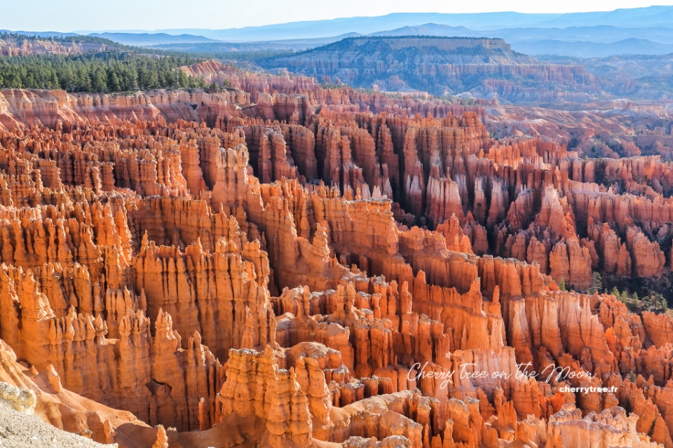
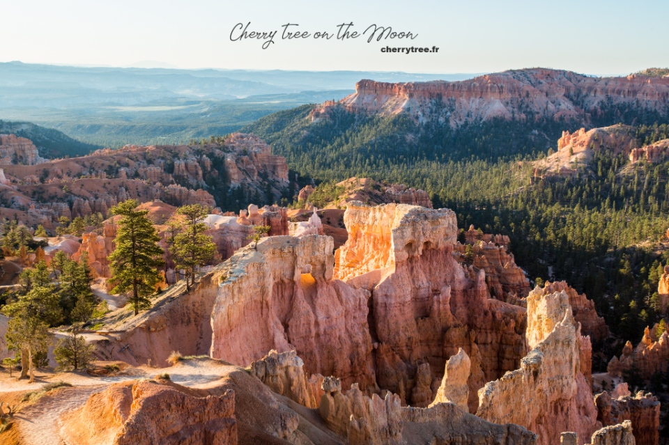
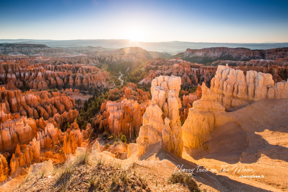
Day 7: Bryce Canyon Np
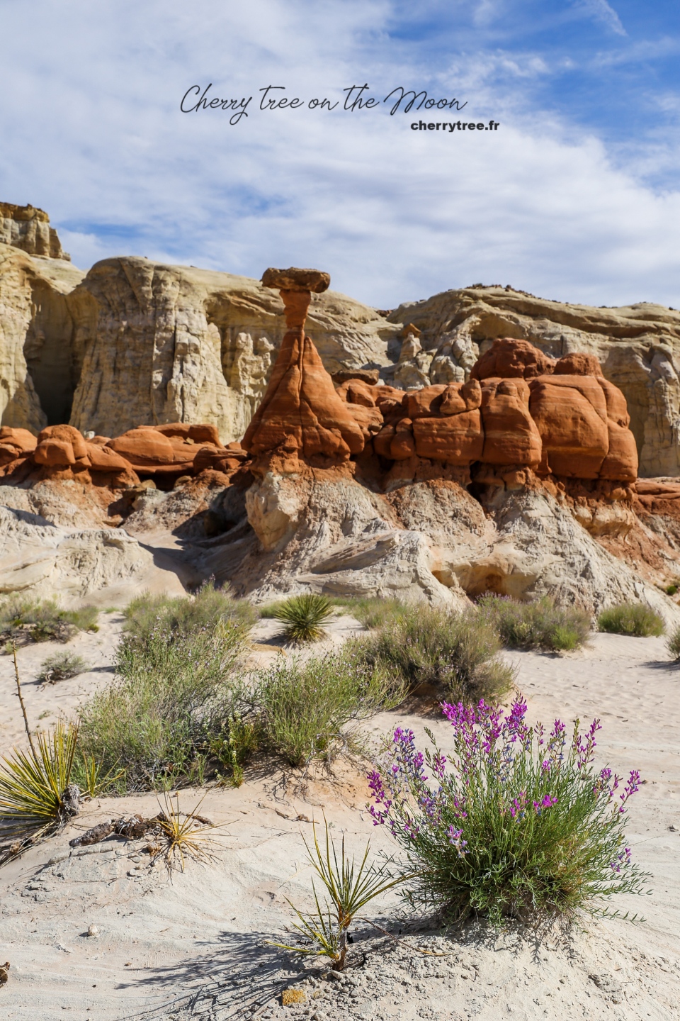
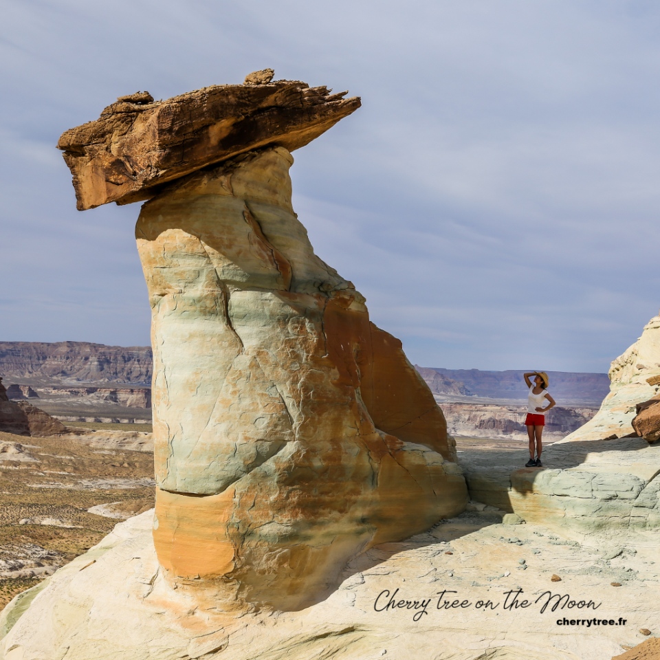
Bryce Canyon is one of the most beautiful national parks in the United States, with a strange landscape, large orange hoodoos rocks (spectacular rock formations formed over thousands of years which protrude from the bottom of an arid drainage basin or badland.) standing close together, unmistakable. Bryce Canyon in the state of Wyoming, covering an area of 145 km². Coming here, you cannot miss the sunrise at the view points. The moment the sun rose, the rays of light threaded between the fiery red stone pillars, it was truly amazing.
- Dawn: Sunrise point
- From Sunrise point, go down hiking Queen Garden trail and Navajo loop trail
- Sunset: Sunset point
- Overnight near Bryce Canyon
Day 8: Bryce Canyon Np
- Morning: Welcome dawn at Sunset Point and Inspiration Point.
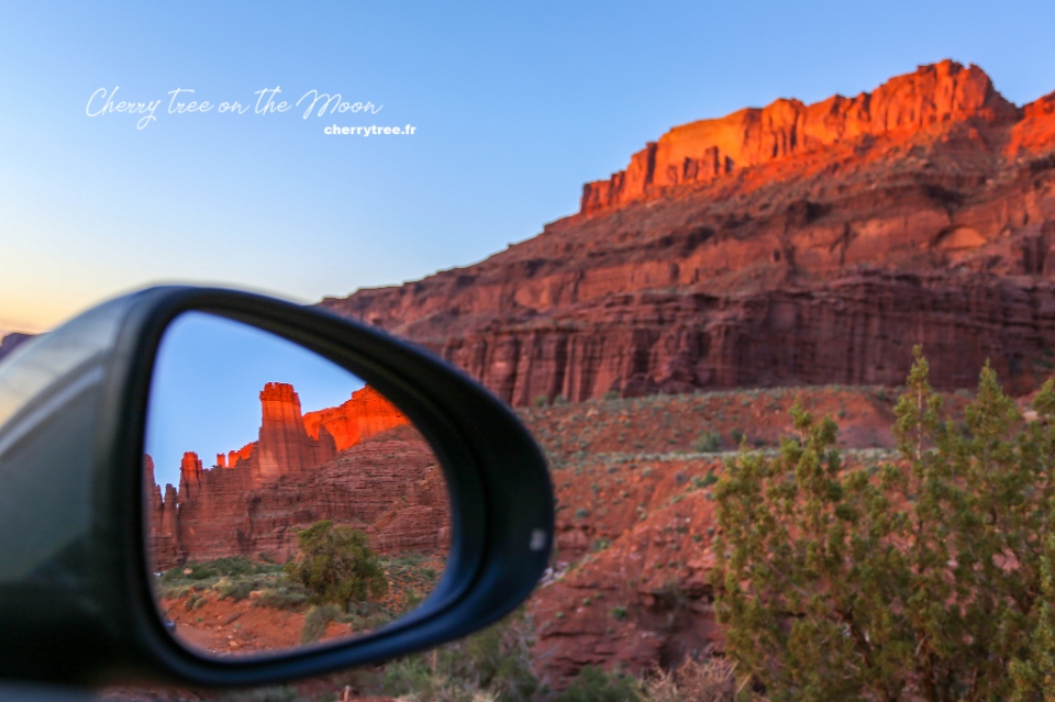
- Driving: Bryce Canyon – Moab (5h, 270 miles) via Scenic byway 12.SB12 is one of the most beautiful roads in America, passing through majestic and very wild landscapes, especially the part between Escalante and Boulder. If you want, you can spend another day day on this road, visiting Escalante National Monument or Capitol Reef National Park.
- Fisher tower sunset near Moab.
- Overnight in Moab.
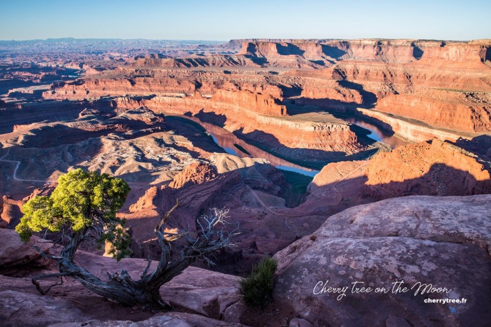
Day 9: Dead Horse Point Sp, Arches Np
- Driving: Moab – Arches NP (9 minutes, 6 miles)
- Dawn at Dead horse point SP. Dead horse point SP is a typical image of a canyon in the American West. From the parking lot, walk a few hundred meters for a better view of the Colorado River and Manti-La Sal mountain.
- Drive from Dead horse point SP to Arches NP. Arches NP is a national park with more than 2000 natural stone arches. Red sandstone terrain, eroded by wind and rain into weird and interesting shapes.
- Hiking Devil garden trail (4.2 miles, 6.8 km), should go in the morning to cool down.
- Visit Windows section, stop by Double arch (0.8 mile, 1.2 km).
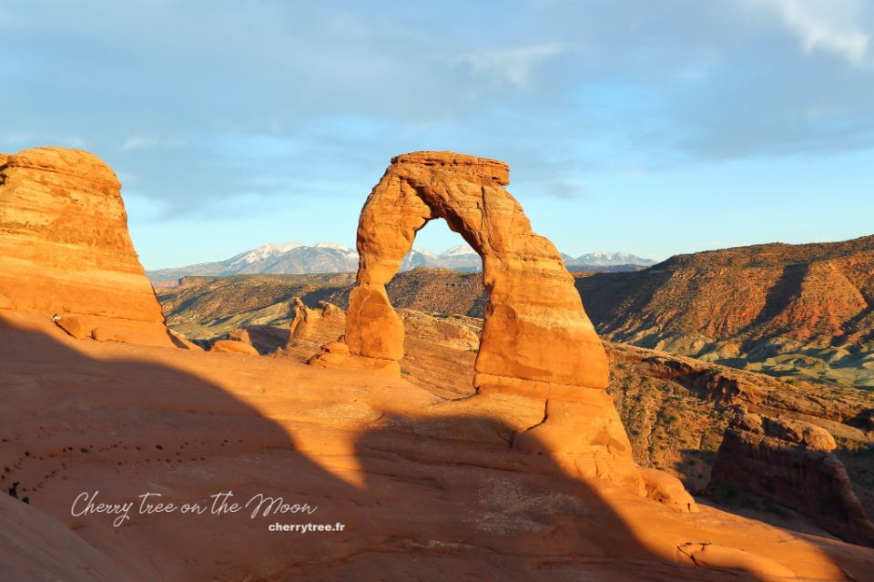
- Late afternoon hiking Delicate arch trail (3.0 miles, 4.8 km). The Delicate arch is the symbol of the state of Utah. You should go late afternoon because Delicate arch is more beautiful at sunset. If you go in the morning, it will be backlit. This trek is very hot because there is no shade, remember to bring at least 1 liter of water per person.
- Overnight in Moab.
Day 10 : Canyonlands Np
- Driving: Moab – Canyonlands NP (45 minutes, 33 miles). Canyonlands is a national park located next to Arches NP. Canyonlands is true to the name “the land of canyons”, is a collection of countless canyons formed by the erosion of two rivers Colorado and Green. Canyonlands is extremely large, including 3 separate areas with 3 different entrances, hundreds of miles apart: Island in the Sky, Needles and The Maze. Because I was so fascinated with the image of Mesa arch, I chose to go to Island in the Sky.
- Dawn at Mesa arch, one of the most beautiful stone arches in America. You should come here before dawn to find a place to find a good spot for your camera in the middle of the forest of professional photographers waiting. From the parking lot to the arch, you have to walk for about 15-20 minutes.
- Drop by Murphy point, White rim overlook, Grand viewpoint, Green River overlook, Shafer Canyon overlook.
- Hiking False Kiva trail (2 miles, 3 km).
- Catch the sunset at the Grand viewpoint or at the Green River Overlook, admiring the scenery of one of the most remote and wild lands in the West.
- Canyonlands – Monticello (1h40, 86 miles)
- Overnight in Monticello.
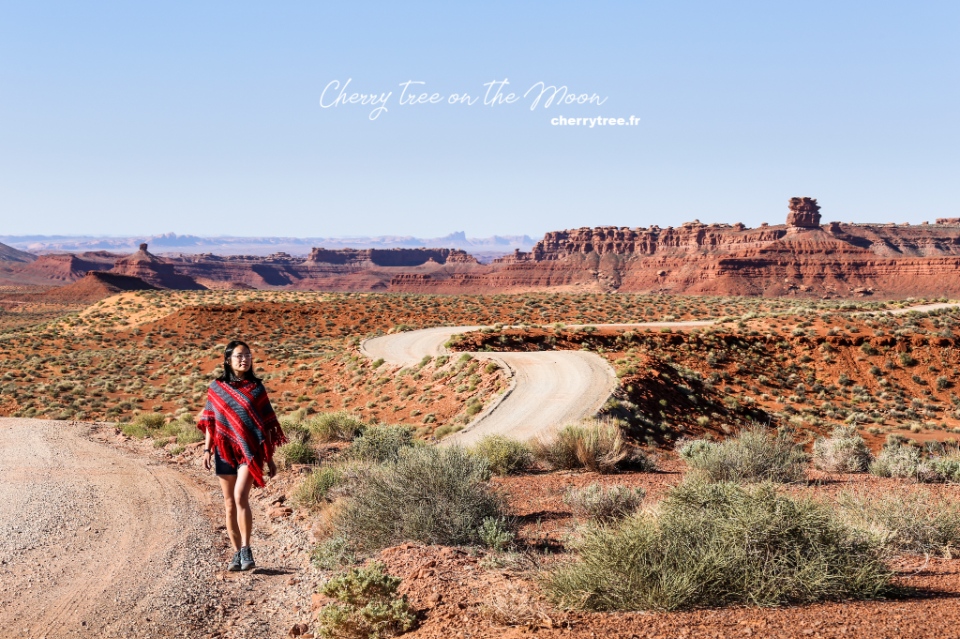
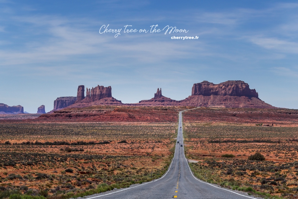
Day 11: Valley Of The Gods, Goosenecks Sp, Monument Valley Navajo Tribal Park (Ntp)
- Driving: Monticello – Monument Valley (1h50, 96 miles), on the way stop by Valley of the Gods https://utah.com/monument-valley/valley-of-the-gods. On the Route 163, turn onto Valley of the Gods road.
- Stop by Goosenecks SP at the intersection of roads 163 and 261 before continue going to Monument Valley. Monument Valley, or Tse’ Bii’ Ndzisgaii in the Navajo language, is a symbol of the Southwest. This place has been used as a backdrop for hundreds of movies, music clips, magazine covers… Monument Valley is owned by the Navajo Nation, so it has its own “rules”, different from state parks or national parks.
- Hiking Wildcat trail (4 miles, 6 km), one of the most beautiful trails in Monument Valley.
- Take a tour around Monument Valley via Scenic Drive in the late afternoon.
- Sunset at the viewpoint right in front of Monument Valley’s Visiter Center.
- Overnight in Monument Valley.
Day 12: Page
- Driving: Monument Valley – Page (2h, 126 miles)
- Strolling Thousand Pockets (2 miles, 3 km)
- Visit Stud Horse Point.
- Overnight in Page.
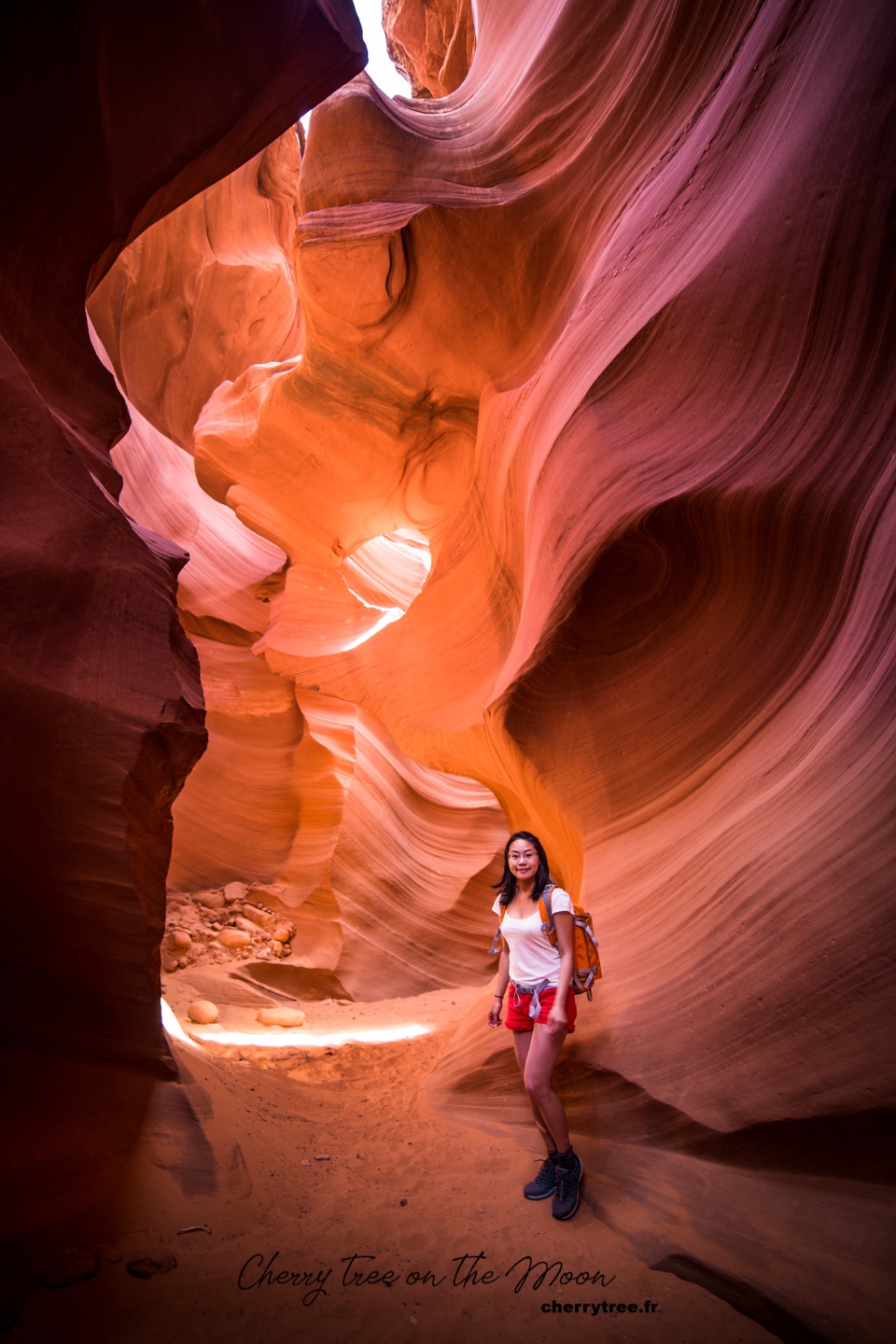
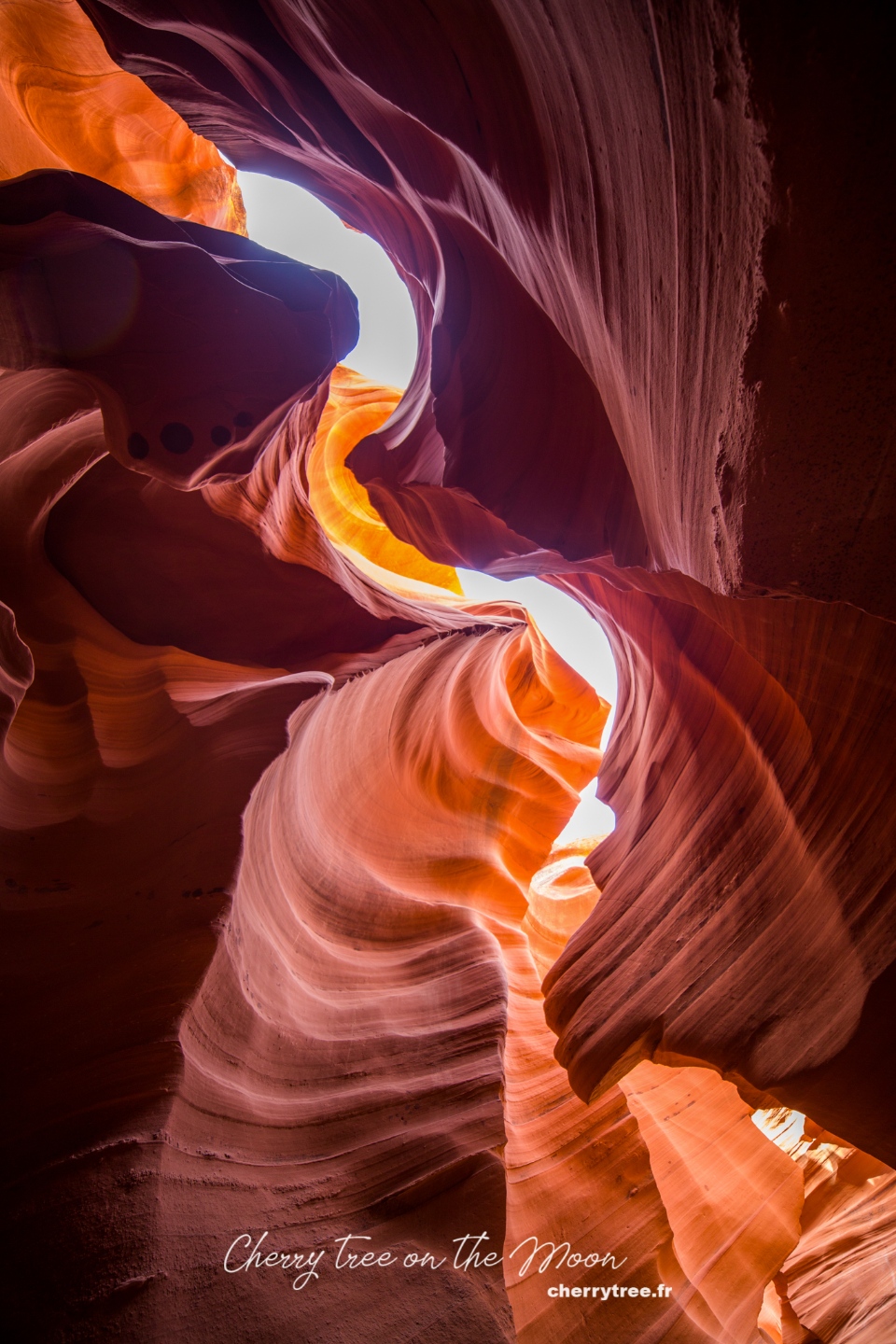
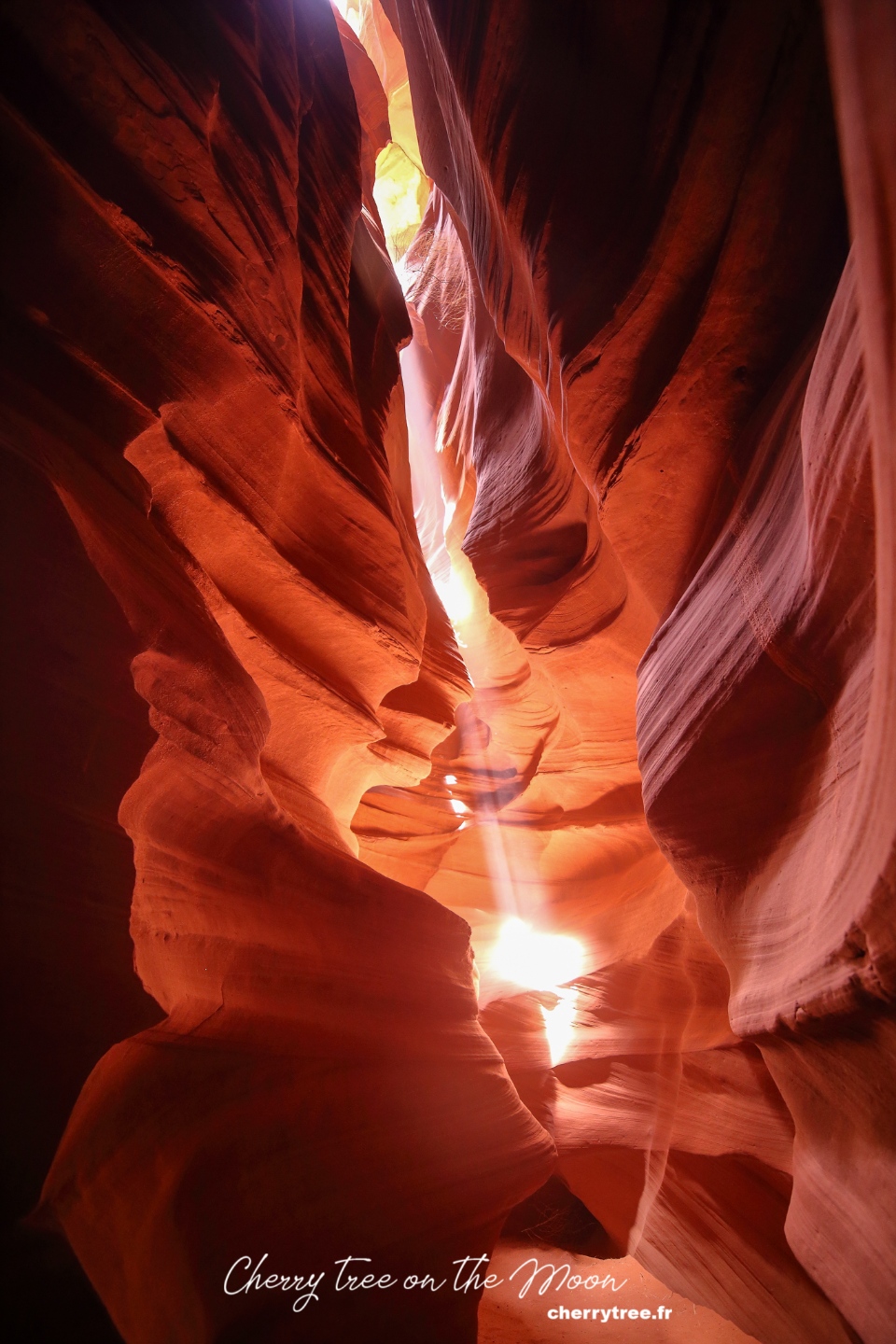
Grand Circle road trip itinerary: Day 13: Antelope Canyon Ntp
Antelope Canyon are two beautiful narrow canyons formed by the process of wind and water abrasion. Antelope Canyon is also managed by the Navajo Nation. Since about 10 years ago, AC has become more and more famous, so the price of admission is very expensive (42-98 USD, 2022 price).
- Visit Lower Antelope Canyon (Hasdeztwazi). Buy a photo pass to travel freely in the canyon). Update 2022: from 2018 there is no longer photo tour for Lower AC.
- Visit Upper Antelope Canyon (Tse Bighanilini’), visiting hours: 11am-1pm to get beautiful light. Update 2022: you need to book several months in advance if you want to enter Upper AC at a nice time frame.
- Overnight in Page.
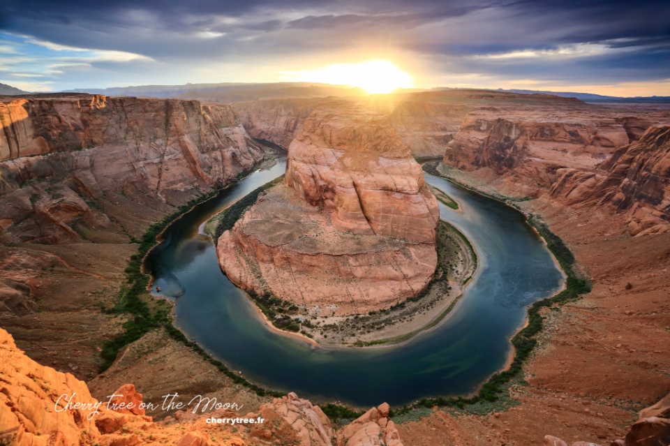
Day 14: Lake Powell, Horseshoe Bend
- Book a tour to explore Lake Powell by boat.
- Catch the sunset at Horseshoe Bend.
- Overnight in Page.
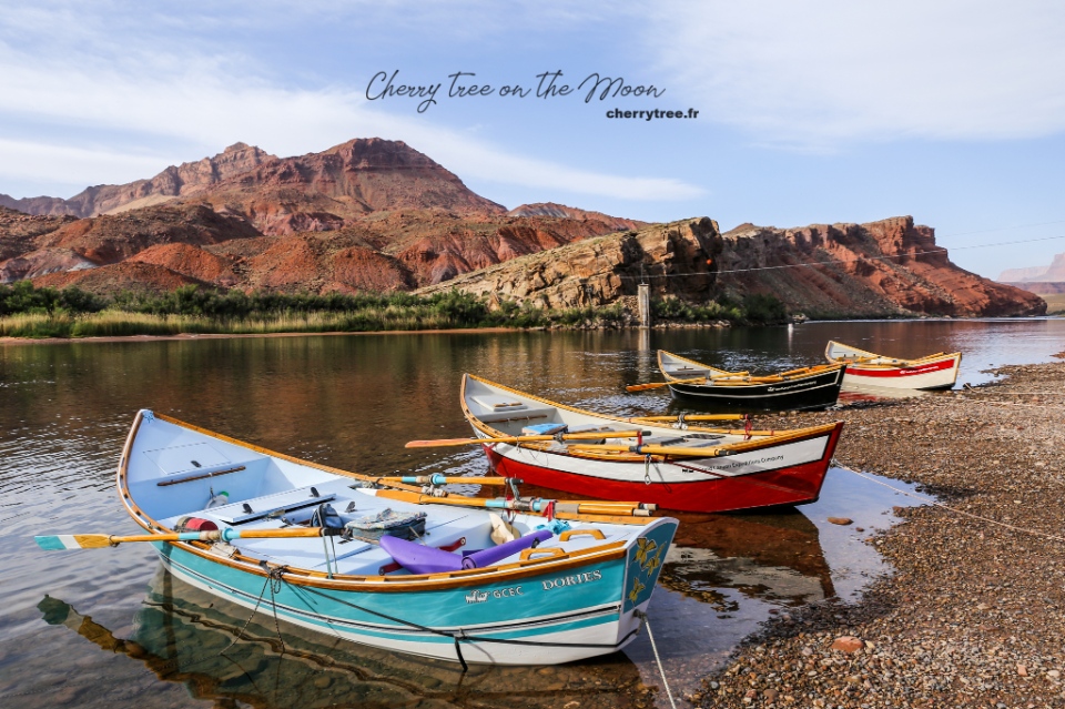
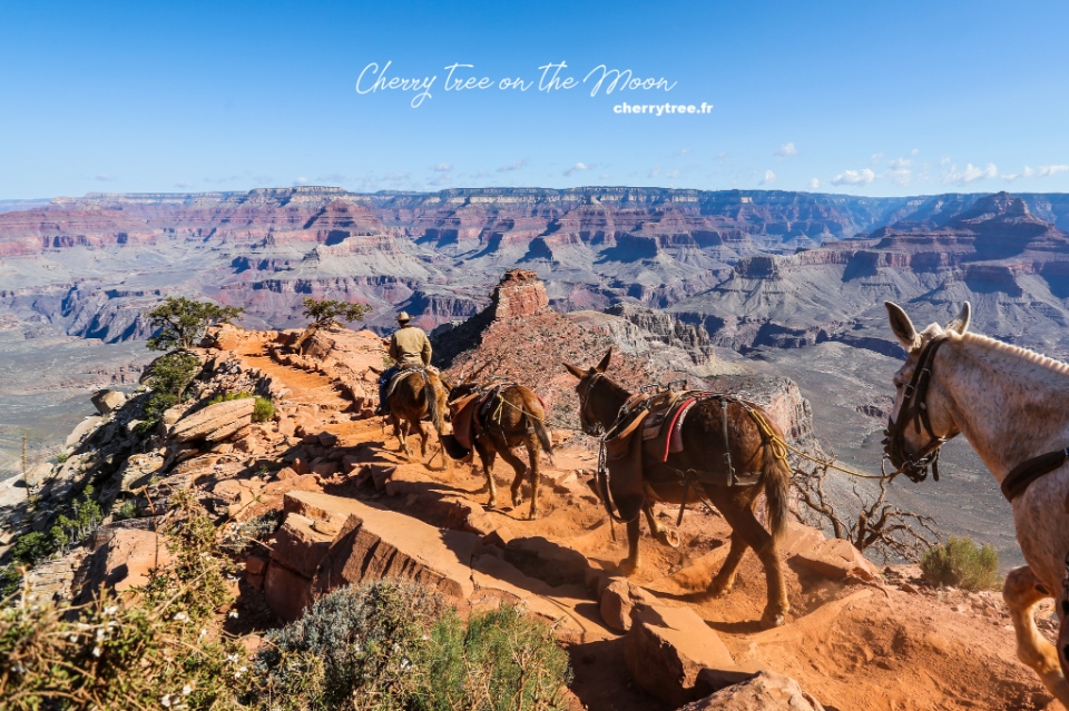
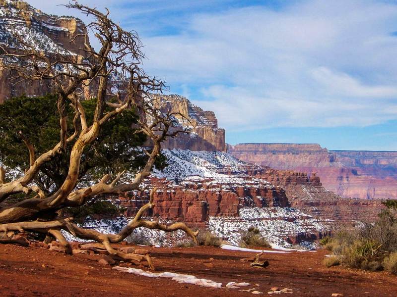
Day 15: Grand Canyon Np
- Driving: Page – Grand Canyon South Rim (2.5 h, 133 miles)
- Drop by Lee’s Ferry.
- Hiking Cathedral Wash (2.5 miles, 3.75 km).
- Stop at Desert View 22 miles from GC, nice light in the afternoon.
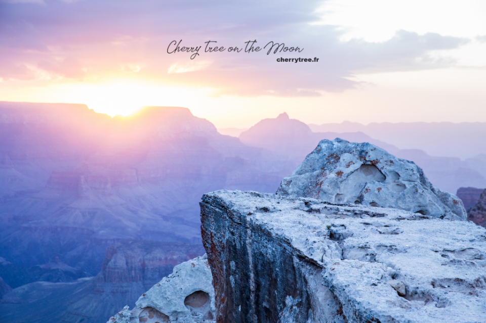
- Overnight in Grand Canyon Village. Grand Canyon is created by the erosion of the Colorado River into the rocky mountain bed, is the largest canyon in the United States. No len can capture the magnificence and overwhelming immensity of the landscape here.
Day 16: Grand Canyon Np
- Dawn at Mather Point.
- Hiking Bright Angel trail to 3-miles Resthouse and back (6 miles, 9.6 km).
- Sunset at Hoppi Point.
- Overnight in Grand Canyon Village.
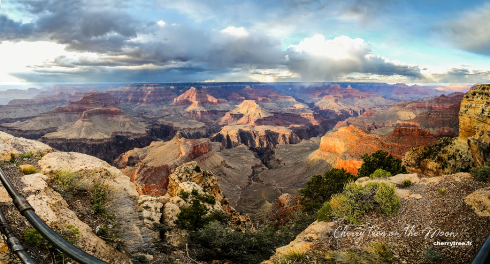
Day 17: Grand Canyon Np
- Dawn at Yaki Point.
- Hiking South Kaibab trail to Cedar Ridge and back (3 miles, 4.8 km).
- Take the trail of Time from Verkamp’s Visitor Center to Yavapai Point (1.9 miles, 3 km).
- Sunset at Yavapai Point.
- Overnight in Grand Canyon Village.
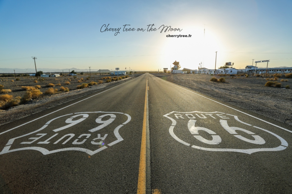
Day 18: Route 66
- Driving: Grand Canyon – Williams – Twentynine Palms (8h, 480 miles).
- Drive along the legendary Road 66 (Route 66): Seligman, Hackberry, Kingman, Oatman, Essex, Newberry Springs.
- Overnight in Twentynine Palms.
Day 19: Joshua Tree Np
- Driving: Twentynine Palms – Joshua Tree National Park.
- Strolling around Hidden Valley, Cholla Cactus Garden.
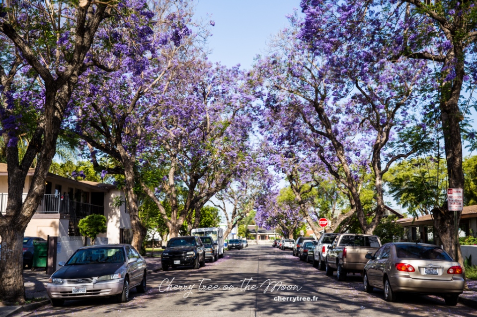
- Driving: Joshua tree park – Santa Ana (2h, 140 miles).
- Purple Santa Ana in May, on the Myrtle Street side, Morrison Park.
- Santa Ana – Los Angeles (1h, 40 miles).
- Overnight in Los Angeles.
Day 20: Los Angeles
- Sightseeing in Los Angeles.
- Overnight in Los Angeles.
Day 21: Los Angeles
- Sightseeing in Los Angeles.
- Return car.
Grand Circle road trip itinerary: When to come?
Grand Circle has mountainous and desert terrain, the weather is quite harsh. Take a roadtrip in spring (March to May) and autumn (September to November) are the two most beautiful seasons. The summer months (June, July, August) are very hot, especially in the Death Valley, the daytime temperature can be reach up to 40, 50 degrees Celsius. And winter is cold and snowy, dangerous if you are not used to driving on wet and icy roads.
Tickets
National Parks and Reserves
National parks and reserves all have a certain entrance fee, from 5 to 10 USD. This fare can be charged on a per capita basis or calculated for everyone in the car. If your itinerary goes through about 5, 7 parks, reserves, national works, you should buy an American The Beautiful Pass.
American The Beautiful Pass:
- Price 80 USD.
- Valid within 1 year from date of purchase.
- The pass takes effect as soon as you pay.
- Usable throughout the United States in all government areas (not counting single states or of Indians).
- Buy at the tourist information center (Tourist office) of the first NP you will come to.
- The pass cover for 1 car and 7 people.
- List of areas where the pass can be used and more information here.
State Parks and Reserves
American The Beautiful pass cannot be used in these areas, additional payment is required. Price from 5 to 10 USD / 1 car. Tickets purchased on the spot.
Navajo Nation Parks
These areas are not administered by the state, but by the Navajo people. Ticket prices are therefore also quite expensive and increasing exponentially. In my itinerary above, there are 2 places in the Navajo Nation, which are Monument Valley and Antelope Canyon.
Tickets to Monument Valley cost 20 USD / 1 car for 4 people, from the 5th person add 6 USD / 1 person.
Accommodation
Hotel
I usually book hotels on famous websites like booking, agoda or expedia. In which Booking is the page with the room in the hierarchy that suits my budget.
The accommodation of NPs
All NPs have lodges with a variety of rooms for tourists, located right in the NP. These lodges are usually a bit more expensive than hotels outside but are in good locations, making it very convenient for visiting the park for several days. You need to go directly to each park’s website to see prices and make reservations.
Camping in NPs
For guests with a more modest budget, NPs also have one or more camping sites. Camping site of NP is very good, with electricity and water, clean bathrooms and toilets. Great for those who love backpacking travel. You only need to bring camping gear (tents, mattresses, cooking utensils…), pay attention to the temperature in the desert at night, it is a bit cold, need to prepare a warm sleeping bag.
Renting a car in the US
I often rent a car on Rentalcars site. This firm has a pretty good service, listing many car companies for you to choose from. I will write a detailed article about renting and driving in the US later.
Reference costs
- Round-trip airfare from Europe: 800 – 1000 USD.
- Hotel: 50 – 100 USD.
- Meal: 10 – 20 USD / 1 person / 1 meal.
- Self-drive car rental 40 – 50 USD / 1 car / 1 day.
Total cost about 5,600 USD / 3 weeks for 2 adults.
Reference books and websites
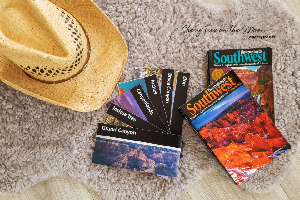
This is my first roadtrip, so I prepared very carefully, read a lot of websites and reference books. Among them, which I find most useful for photography enthusiasts like myself, is the 3-book “Photographing the Southwest” series by Laurent Marthès.
For those of you who know French, you can refer to the website RoadTrippin, an “encyclopedia” of roadtrips in the US. I found a lot of good information there.
I have a lot of maps of NPs that I have passed, if you need them, please message me to scan.
Read more US guide here.


