Laugavegurinn/Fimmvörðuháls Pass, Iceland
Best For: Vulcanists and hikers who want to see Icelandic wilderness while spending the night in huts
Round-Trip: About 48 miles
One of the most popular hiking routes in Iceland was closed when the Eyjafjallajökull volcano erupted in spring 2010, bringing air traffic across the Atlantic to a halt. The first eruption actually occurred on Fimmvörðuháls Pass—the high spit of land between Eyjafjallajökull and the larger Mýrdalsjökull ice cap—covering the trail in volcanic rocks, which is just a small part of what makes this route so magical. But a reroute of the trail has opened since the volcano stopped erupting in May 2010. It is even better for taking in the new twin craters of Magni and Móði, which were named after the sons of Thor, the hammer-wielding thunder god. But the chance to peer into recent volcanic destruction is just a small part of this route’s appeal.
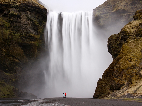
A quarter of the population of the island claims to believe in elves or other mythical creatures, and after hiking through the lava fields and mountains of this route, you may begin to believe as well. It’s a visceral landscape, with the ice caps of two glaciers and the raging North Atlantic on the horizon. The route winds down into Thórsmörk (literally “Thor’s wood”), a park that even harbors a few trees, a relative rarity here. Along the way, well-maintained huts house foreigners and plenty of native Icelanders. The final walk from Fimmvörðuháls to Skógar runs along a ravine filled with waterfall after waterfall and ending in the massive 200-foot-high cascade of Skógafoss. If Katla does erupt, the trail could be closed or change, so do this hike soon.
When to Go: The huts are open from late June to mid-September. It’s an Icelandic tradition to hike Fimmvörðuháls Pass on the summer solstice, so you’ll have company then. In fact, the whole route is so popular that it’s referred to as “Laugavegur,” the name of the main boulevard in Reykjavik.
Shortcut: You can also simply hike Fimmvörðuháls Pass from Thorsmork to Skógafoss, covering 12 to 14 miles over a long day.
Insider Tip: Despite the remote location, buses run from Reykjavik to the starting point at Landmannalaugar hut during the summer.










![10 best airports in Asia in 2016 [RANKED] kuala-lumpur-international-airport-best airports in asia in 2016 by skytrax ratings](https://livingnomads.com/wp-content/uploads/2016/08/29/kuala-lumpur-international-airport-best-airports-in-asia-in-2016-by-skytrax-ratings-218x150.jpg)


